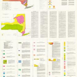
The datasets of the NYS Museum which are posted here are made freely available. Use of this data implies you understand the disclaimer associated with it. Our Metadata references are available from the NYS GIS Clearinghouse.


Panel Image

Geographic Information System (GIS)
See also
Boundary Data
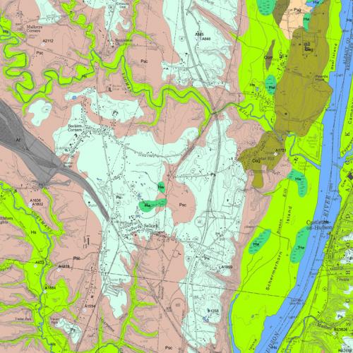
This Index Map shows ArcInfo coverages for the State of New York. Statewide coverages are "clipped" to the boundaries of these sheets to coincide with source maps.

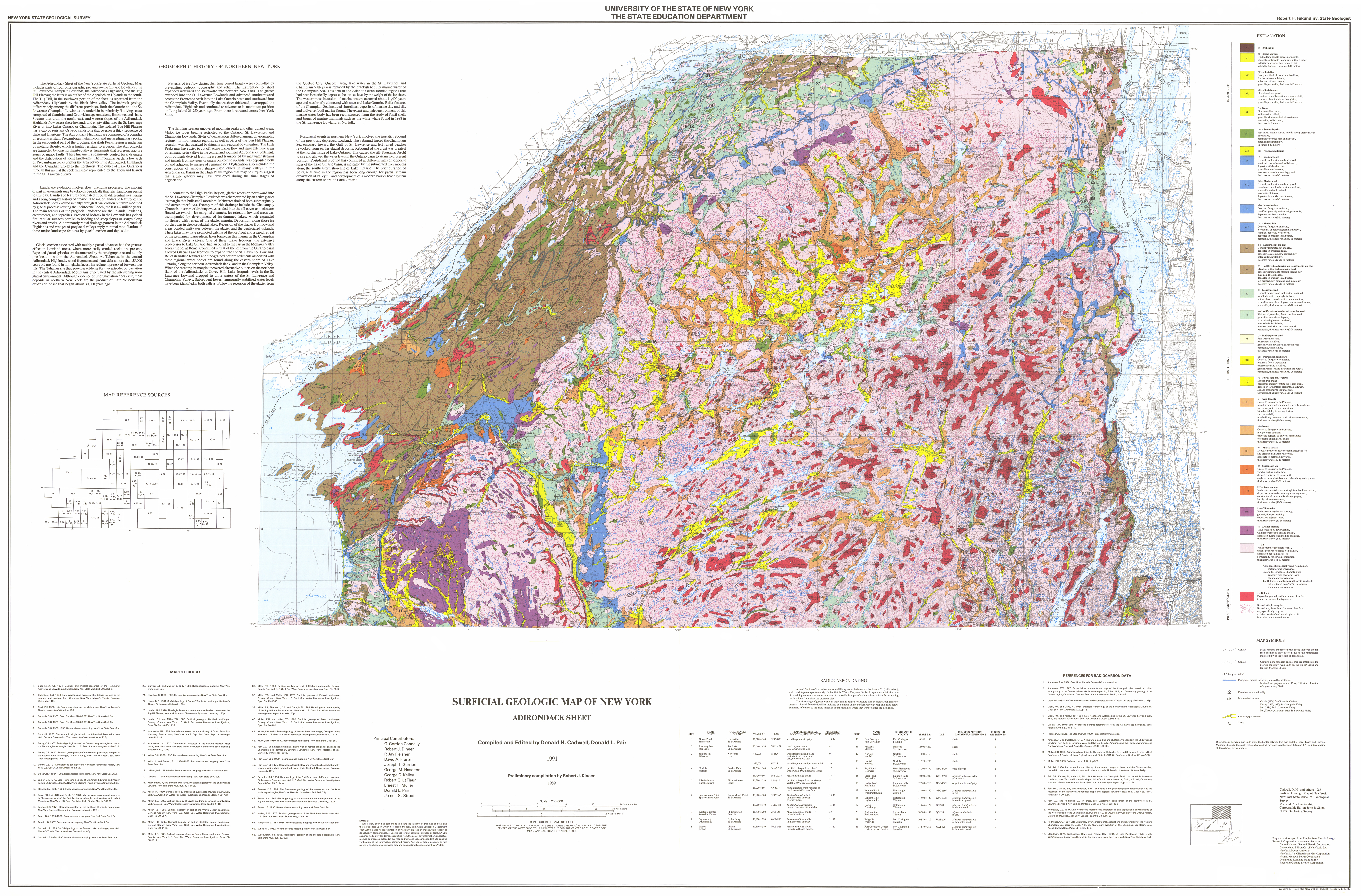
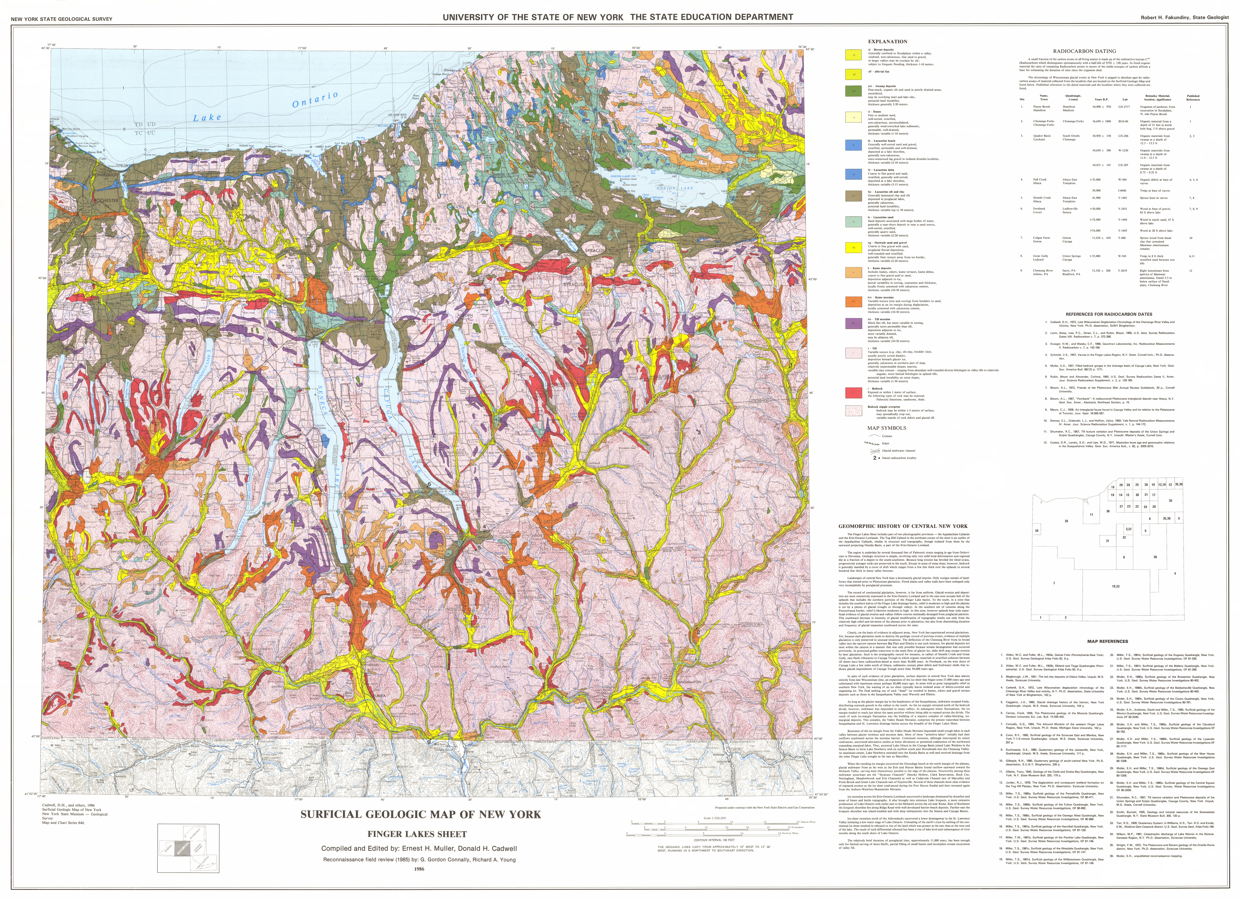
Surficial Geology Shape Files
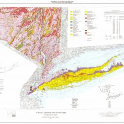
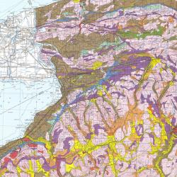
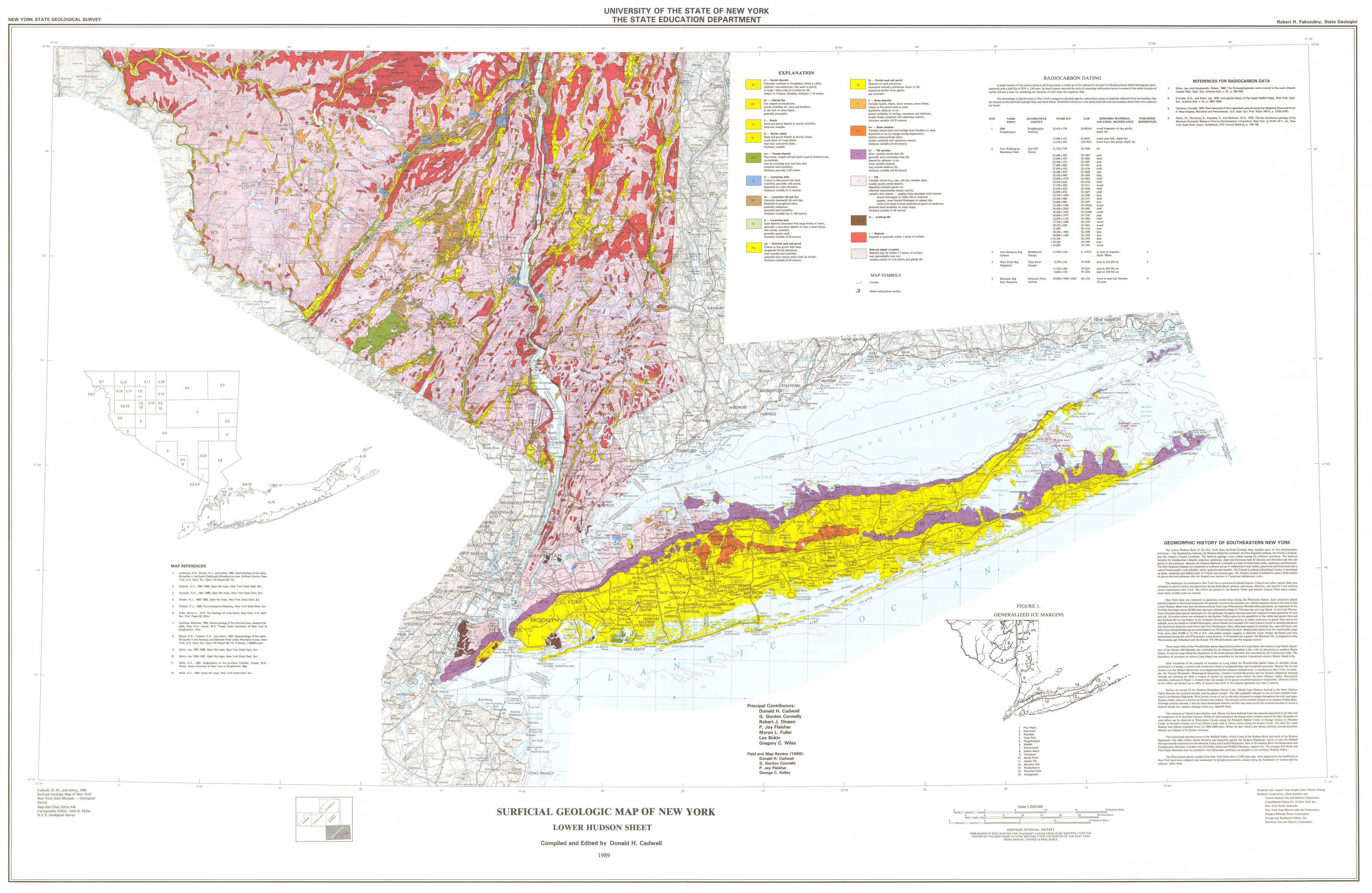
Surficial Geology Material Explanation
For a complete explanation, see Map & Chart Series Number 40
available from the NYS Museum Publications Department
http://www.nysm.nysed.gov
af - Artificial fill
al - Recent alluvium
Oxidized fine sand to gravel, permeable,
generally confined to flood plains within a valley,
in larger valleys may be overlain by silt,
subject to flooding, thickness 1-10 meters,
alf - Alluvial fan
Poorly stratified silt, sand, and boulders,
fan shaped accumulations,
at bottoms of steep slopes,
generally permeable, thickness 1-10 meters.
alt - Alluvial terrace
Fluvial sand and gravel,
occasional laterally continuous lenses of silt,
remnants of earlier higher flood plains,
generally permeable, thickness 1-10 meters.
b - Beach
Sand and gravel deposit at marine shorelines,
thickness variable.
co, col - Colluvium
Mixture of sediments,
deposited by mass wasting,
thickness generally 1 - 5 meters.
cof - Colluvial fan
Fan shaped accumulation,
mixture of sediments,
at mouths of gullies,
thickness generally 1 - 5 meters.
d - Dunes
Fine to medium sands,
well sorted, stratified,
generally wind-reworked lake sediment,
permeable, well drained,
thickness 1-10 meters.
pm - Swamp deposits
Peat-muck, organic silt and sand in poorly drained areas,
unoxidized,
commonly overlies marl and lake silt,
potential land instability,
thickness 2-20 meters.
alp - Pleistocene alluvium
lb - Lacustrine beach
Generally well sorted sand and gravel,
stratified, permeable and well drained,
deposited at lake shoreline,
generally non-calcareous,
may have wave-winnowed lag gravel,
thickness variable (1-5 meters).
mb - Marine beach
Generally well sorted sand and gravel,
elevation at or below highest marine level,
permeable and well drained,
may be fossiliferous,
deposited in brackish to salt water,
thickness variable (1-5 meters).
ld - Lacustrine delta
Coarse to fine gravel and sand,
stratified, generally well sorted,
deposited at a lake shoreline,
thickness variable (3-15 meters).
md - Marine delta
Coarse to fine gravel and sand,
elevation at or below highest marine level,
stratified, generally well sorted,
deposited in brackish to salt water,
permeable, thickness variable (3-15 meters).
lsc - Lacustrine silt and clay
Generally laminated silt and clay,
deposited in proglacial lakes,
generally calcareous, low permeability,
potential land instability,
thickness variable (up to 50 meters).
sc - Undifferentiated marine and lacustrine silt and clay
Elevation within highest marine level,
generally laminated to massive silt and clay,
may include fossil shells,
deposited in brackish to salt water,
low permeability, potential land instability,
thickness variable (up to 50 meters).
ls - Lacustrine sand
Generally quartz sand, well sorted, stratified,
usually deposited in proglacial lakes,
but may have been deposited on remnant ice,
generally a near-shore deposit or near a sand source,
permeable, thickness variable (2-20 meters).
s - Undifferentiated marine and lacustrine sand
Well sorted, stratified, fine to medium sand,
generally a near-shore deposit,
at or below highest marine level,
may include fossil shells,
may be a brackish to salt water deposit,
permeable, thickness variable (2-20 meters).
d - Wind-deposited sand
Fine to medium sand,
well sorted, stratified,
generally wind-reworked lake sediments,
permeable, well drained,
thickness variable (1-10 meters).
og - Outwash sand and gravel
Coarse to fine gravel with sand,
proglacial fluvial deposition,
well rounded and stratified,
generally finer texture away from ice border,
permeable, thickness variable (2-20 meters).
fds - Fluvial deltaic sand
Same as outwash sand and gravel,
except deposition further from glaciers,
age uncertain.
fg - Fluvial sand and/or gravel
Sand and/or gravel,
occasional laterally continuous lenses of silt,
deposition farther from glacier than outwash,
age and proximity to ice uncertain,
permeable, thickness variable (1-20 meters).
k - Kame deposits
Coarse to fine gravel and/or sand,
includes kames, eskers, kame terraces, kame deltas,
ice contact, or ice cored deposition,
lateral variability in sorting, texture
and permeability,
may be firmly cemented with calcareous cement,
thickness variable (10-30 meters).
ki - Inwash
Coarse to fine gravel and/or sand,
interpreted as alluvium
deposited adjacent to active or remnant ice
by streams of nonglacial origin,
thickness variable (2-20 meters).
usda - Undifferentiated stratified drift assemblage
Dominantly clay, silt and sand,
limited gravel and diamicton,
stratification includes undisturbed and deformed laminations,
ice-contact structures,
lenticular, discontinuous bodies of gravel and flow till,
may represent dead-ice, disintegration and local ice-contact lake deposits
in ice-marginal and subglacial environments.,
Thickness variable (10 - 30 meters).
ali - Alluvial inwash
Deposited between active or remnant glacier ice
and draped on adjacent valley wall,
lacks kettles, permeability varies,
thickness variable (2-10 meters).
sf - Subaqueous fan
Coarse to fine gravel and/or sand,
variable texture and sorting,
deposited adjacent to glacier with
englacial or subglacial conduit debouching in deep water,
thickness variable (5-30 meters).
km - Kame moraine
Variable texture (size and sorting) from boulders to sand,
deposition at an active ice margin during retreat,
constructional kame and kettle topography,
locally, calcareous cement,
thickness variable (10-30 meters).
tm - Till moraine
Variable texture (size and sorting),
generally low permeability,
deposition adjacent to ice,
thickness variable (10-30 meters).
ta - Ablation moraine
Till, deposited by downwasting,
with minor amounts of sand and silt,
deposition during final melting of glacier,
thickness variable (1-10 meters).
cd - Colluvial diamicton
Mixture of sediments,
unique to region beyond Wisconsinan glacial limit,
rebedded saprolite and glacial debris,
may be old (Illinoian) drift,
homogenized by varying degrees of colluviation,
bedrock may sporadically crop out or be within 1 - 3 meters of the surface.
t - Till
Variable texture (boulders to silt),
usually poorly sorted sand-rich diamict,
deposition beneath glacier ice,
permeability varies with compaction,
thickness variable (1-50 meters).
Adirondack tills: generally sand-rich diamict,
metamorphic provenance.
Ontario-St. Lawrence-Champlain tills:
generally silty clay to silt loam,
sedimentary provenance.
Tug Hill tills: generally stony silt-clay to sandy silt,
differentiated from "ta" in this region,
sedimentary provenance.
r - Bedrock
Exposed or generally within 1 meter of surface,
in some areas saprolite is preserved.
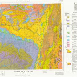
Surficial Geology Color Chart of the NYSGS
The following symbols are used to plot the NYSGS Suficial maps, and are designed for use with a Calcomp electrostatic plotter.
They have been used with an HP-Inkjet Plotter and Tektronix phaser.
The symbol number will have to be modified depending on the plotter being used, as color is VERY HARDWARE SPECIFIC.
The Symbolset comes from ArcInfo: Calcomp1.shd. The symbolset can be imported into ArcView.
In the future, we will have an ArcView legend available.
SURFICIAL SYMBOL
alp 739
al 739
co 739
cof 739
alt 739
d 17
mb 473
lb 473
ld 473
md 473
lsc 37
sc 37
ls 742
s 742
og 31
fg 31
ki 123
ali 123
k 123
sf 186
km 186
tm 417
ta 417
udc 377
r 235
h2o 724
cd 761
usd 123
af 41
bi 739
b 739
to 417
c 739
af 739
t 377
du 123
wt 604
cs 300
.787
Alluvium: Recent floodplain deposits; most are sandy with silt, clay, or
organic lenses as minor constituents. Low terraces that mimic
irregularities of stream gradient are mapped as alluvium.
.787
Fluvial Terrace: Stream terraces are mapped as fluvial terrace. Fluvial
Terrace is mapped rather than outwash where there is no obvious source for
outwash, or where fluvial deposits grade toward, rather than away from, a
presumed glacier margin.
.787
Colluvium: Unsorted mixture of fine to coarse material. Colluvium is
mapped only where deposits are obvious, otherwise it is designated till.
Much of the diamict mapped as till may well be till-derived colluvium,
particularly on the lower portion of steep valley walls.
.976
Paludal Sediment: Organic silt, sand, and organic accumulations
deposited in swamps or marshes.
.72
Ice-Contact Stratified Drift: Coarse to fine sand and/or gravel.
Inferred where constructional topography suggests collapse of subjacent
ice, and by characteristic topography above outwash terraces. Numbers
1-4 refer to morpho-sequences described below.
.31
Outwash: Coarse to fine gravel with sand; restricted to valley bottoms
and stream terraces; numbers 1-4 refer to morpho-sequences described below.
.725
Lacustrine Sand: Sand deposited as deltas and beaches in large
proglacial lakes; may be gradational with outwash. Numbers 1-4 refer to
morpho-sequences described below.
.37
Lacustrine Clay: Lake clay; or laminated silt, silt and clay, or silty
clay; deposited in proglacial lakes.
.61
Glacial Till: Mixture of clay, silt, sand to boulder sized material in
varied proportions; unsorted to poorly sorted; deposited beneath glacial
ice; till is generally more than 2 meters thick.
.417
Glacial Till: As above, but generally 1-2 meters thick; overlies bedrock
which may crop out sporadically.
.109
Superglacial Till: Similar to till described above, but less compact and
commonly contains pockets and stringers of stratified drift or matrix
deficient till; generally 1-2 meters thick.
.2
Bedrock: Exposed or generally within 1 meter of the surface.
.724
Water
.739
Recent alluvium: Oxidized fine sand to gravel, permeable, generally
confined to floodplains within a valley, in larger valleys may be
overlain by silt, subject to flooding, thickness 1-10 meters.
.37
Undifferentiated marine and lacustrine silt and clay: Elevation within
highest marine level, generally laminated to massive silt and clay, may
include fossil shells, deposited in brackish to salt water, low
permeability, potential land instability, thickness variable
(up to 50 meters).
.17
Dune sand: Fine to medium sands, well sorted, stratified, generally
wind-reworked lake sediment, permeable, well drained, thickness
1-10 meters.
.883
Swamp Deposits: Peat, muck, organic silt, and sand deposits in poorly
drained areas, thickness is variable (1-5 meters).
.235
Bedrock: Exposed or generally within 1 meter of surface, in some areas
saprolite is preserved.
.742
Undifferentiated marine and lacustrine sand: Well-sorted, stratified,
fine to medium sand, generally a near-shore deposit, at or below highest
marine level,may include fossil shells, may be a brackish to salt water
deposit, permeable, thickness variable (2-20 meters).
.377
Till: Till in a sheet showing little or no morainal topography, variable
texture (boulders to silt), generally silty clay to silt loam, sedimentary
provenance, usually poorly sorted sand-rich diamict, deposition beneath
glacier ice, permeablility varies with compaction, thickness variable
(1-50 meters).
.604
Winnowed till: Gravel left when waves of the lakes or Champlain Sea
"winnowed" out the clay, silt and fine sand of the till to leave
coarse, poorly rounded gravel.
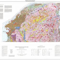
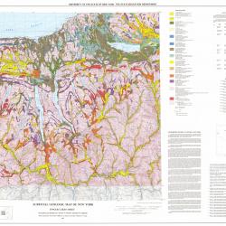
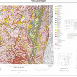
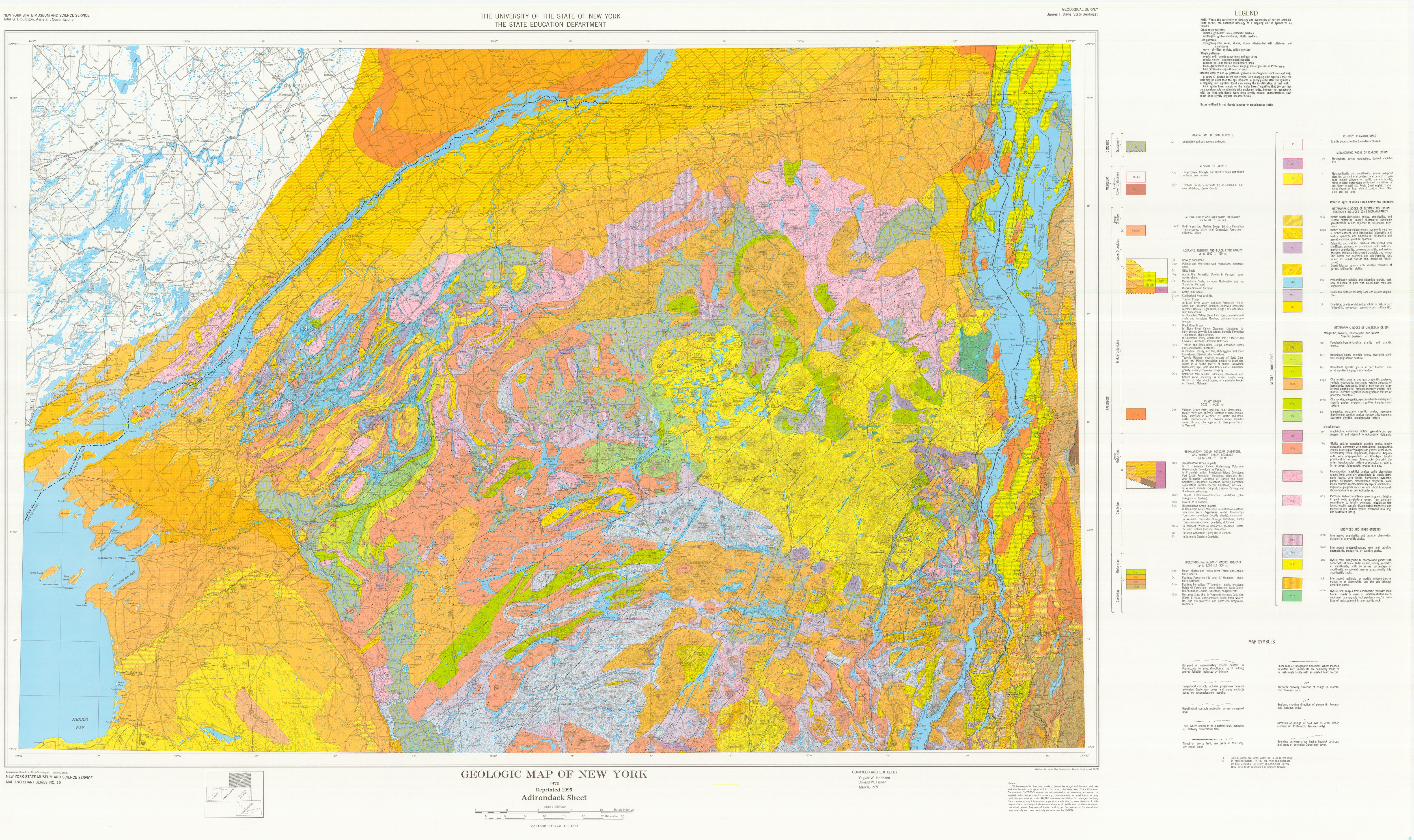
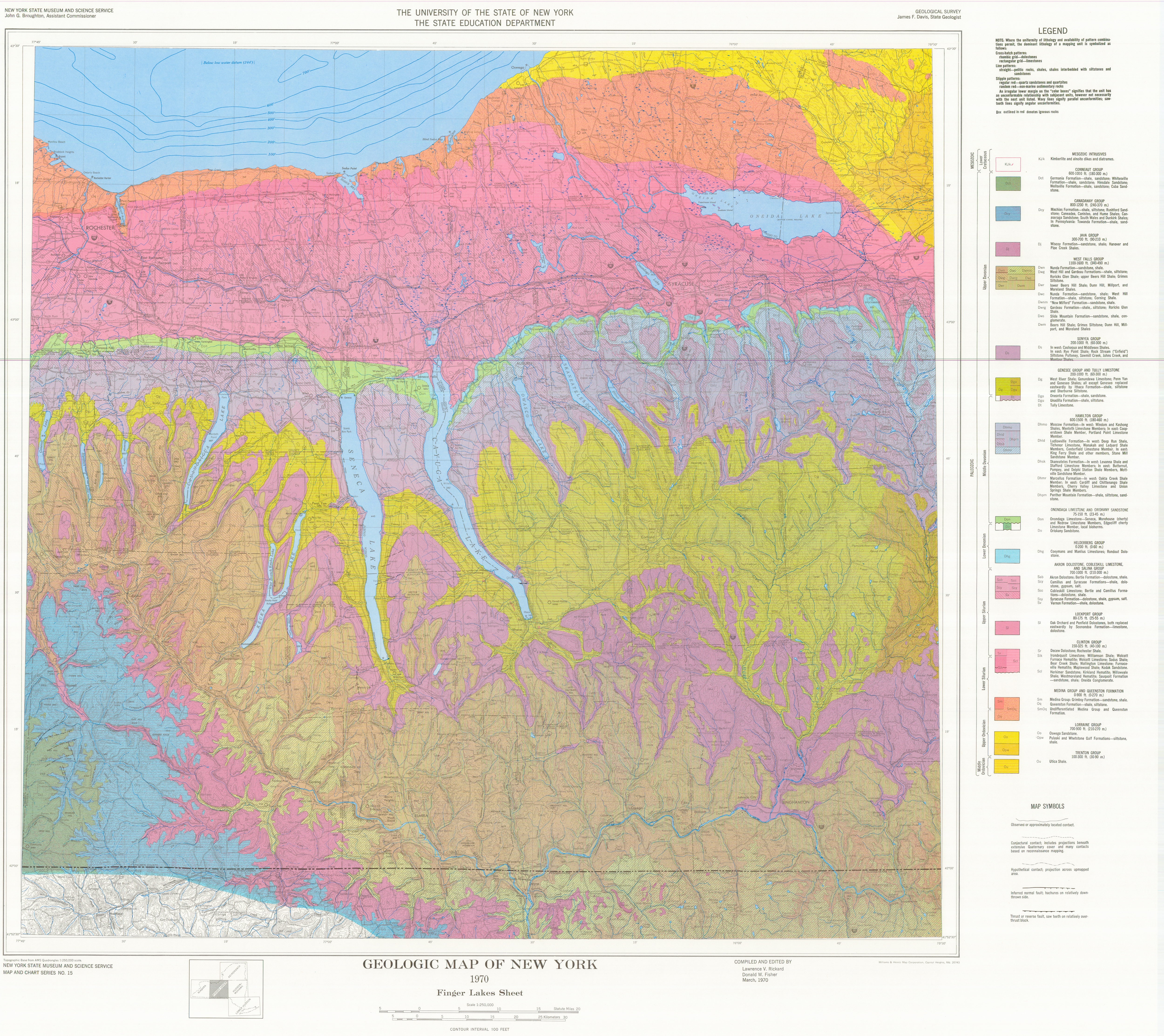
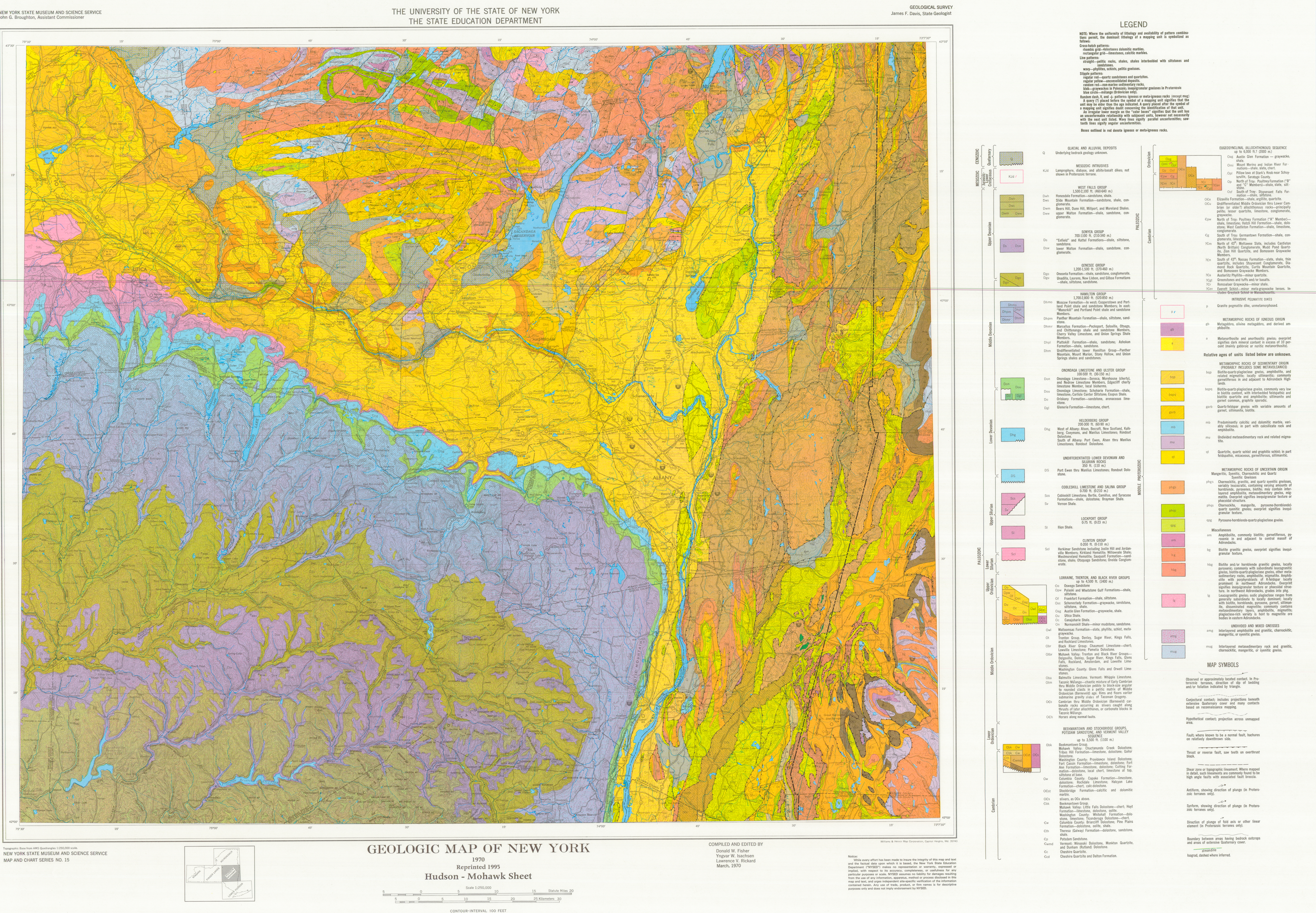
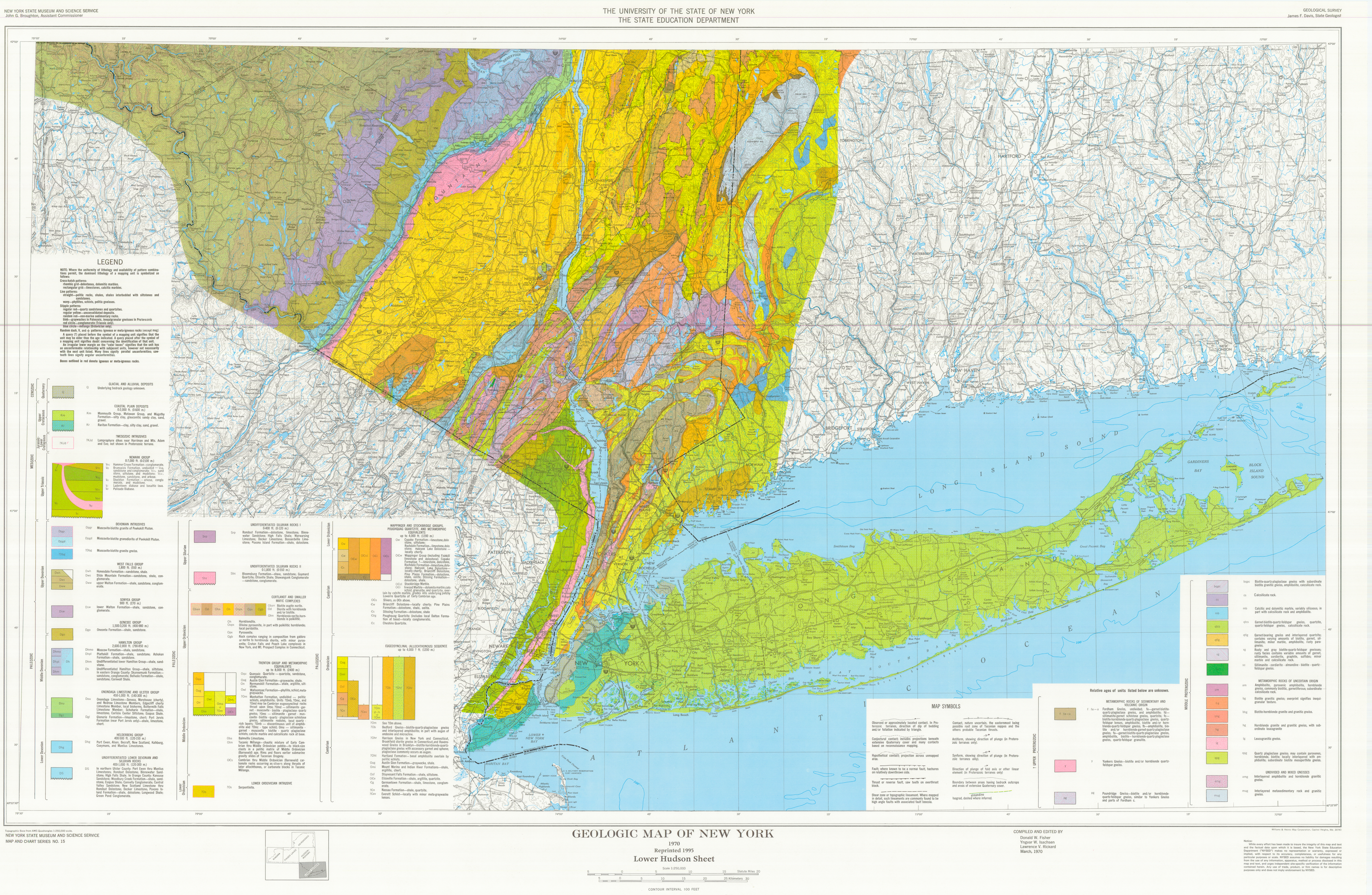
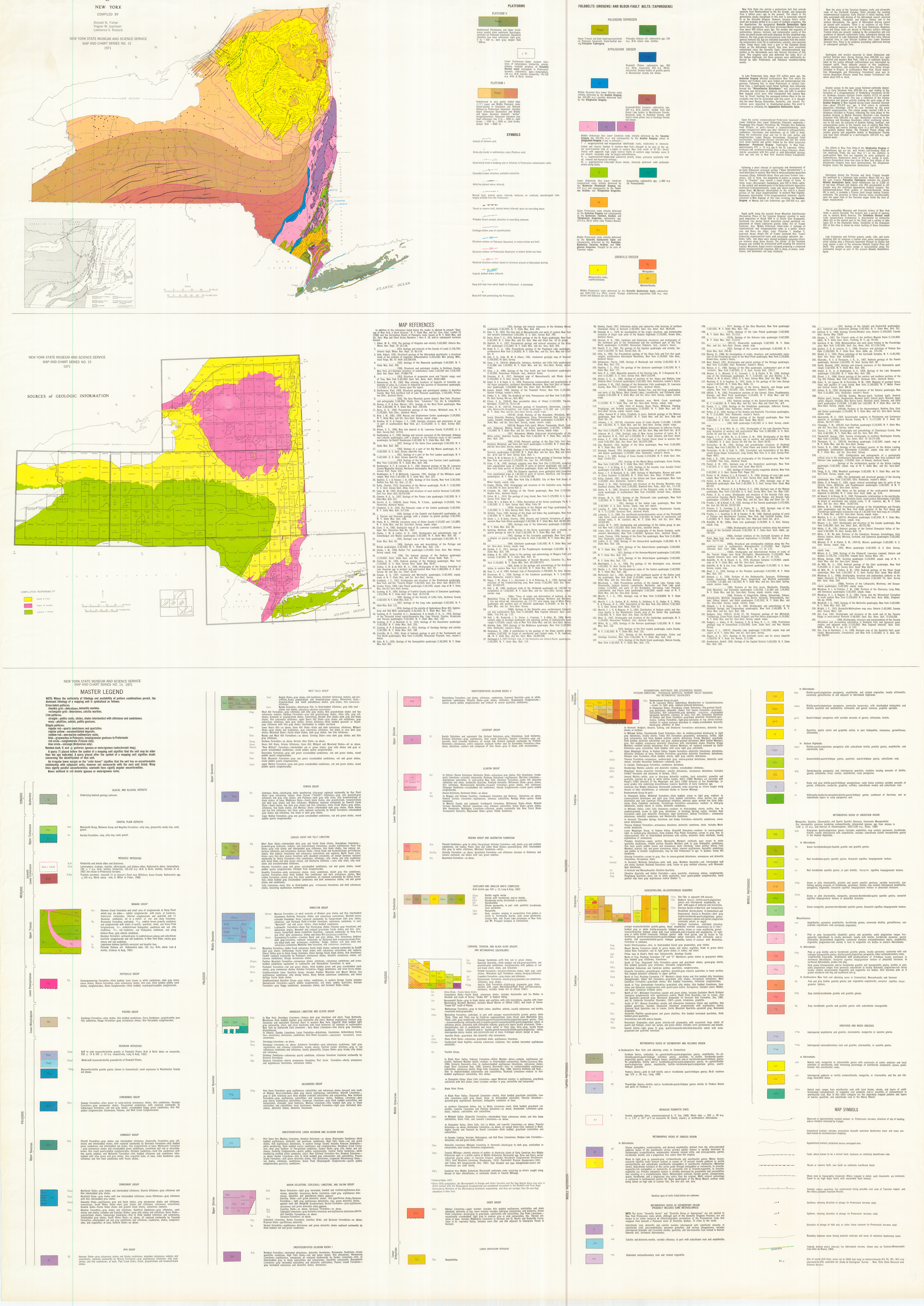
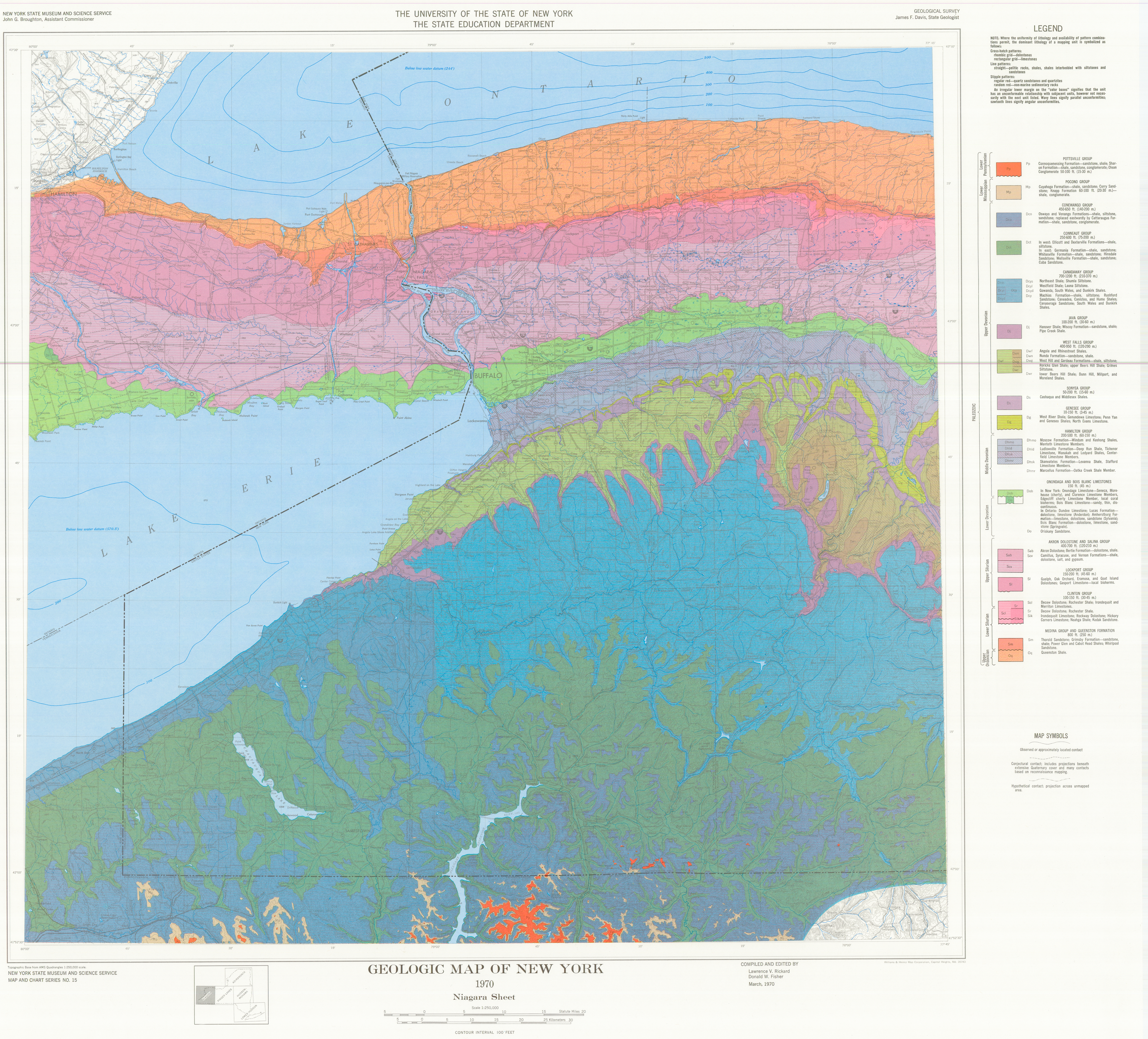
Bedrock Geology Shape Files
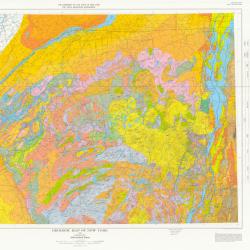
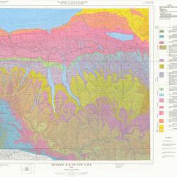

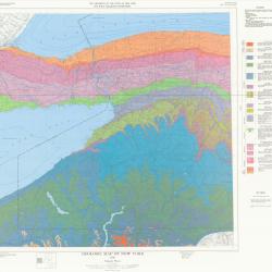
Bedrock Geology Legend: Explanation of bedrock materials
NYS Museum
NYS Geological Survey
Bedrock Attributes
version 1.0 , 7-26-1999
.14
Q 1 GLACIAL AND ALLUVIAL DEPOSITS
.377
2 COASTAL PLAIN DEPOSITS
Km Monmouth Group, Matawan Group and Magothy Formation
Kr Raritan Formation
.382
3 MESOZOIC INTRUSIVES
KJk Kimberlite and alnoite dike and diatreme
KJd Lamprophyre, trachyte, ryolite, albite-basalt, and diabase dikes
.433
KJtp Trachyte porphyry
.394
4 NEWARK GROUP
Trhc Hammer Creek Formation
Trb Brunswick Formation
Trs Stockton Formation
Trl Ladentown Diabase
Trp Palisade Diabase sill
.999
5 POTTSVILLE GROUP
Pp Connoquenessing Formation
.967
6 POCONO GROUP
Mp Cuyahoga Formation
.728
7 DEVONIAN INTRUSIVES
Dpgr Muscovite-biotite granite
Dpgd Muscovite-biotite granondiorite
Dbg Muscovite-biotite granite gneiss
.728
8 CONEWANGO GROUP
Dco Osway Formation
.728
9 CONNEAUT GROUP
Dct Ellicott Formation
.728
10 CANADAWAY GROUP
Dcys Northeast Shale
Dcyl Westfield Shale
Dcyd Gowanda Shale
Dcy Machias Formation
.728
11 JAVA GROUP
Dj Hanover Shale
.728
12 WEST FALLS GROUP
Dwf Angola Shale
Dwn Nunda Formation
Dwg West Hill Formation
Dwr Lower Beers Hill
Dwc Nunda Formation, West Hill Formation
Dwrg Gardeau Formation
Dwm Beers Hill Shale
Dwnm "New Milford" Formation
Dwh Honesdale Formation
Dws Slide Mountain Formation
Dww Upper Walton Formation
.728
13 SONYEA GROUP
Ds Cashaqua Shale
Dsw Lower Walton Formation
.728
14 GENESEE GROUP AND TULLY LIMESTONE
Dg West River Shale
Dgo Oneonta Formation
Dgu Unadilla Formation
Dt Tully Limestone
.739
15 HAMILTON GROUP
Dhmo Moscow Formation
Dhld Ludlowville Formation
Dhsk Skaneateles Formation
Dhpm Panther Mountain Formation
Dhpl Plattekill Formation
Dhmr Marcellus Formation
Dhm Undifferentiated Lower Hamilton Group
Dh Undifferentiated Hamilton Group
.739
16 ONONDAGA LIMESTONE AND TRISTATES GROUP
Dob Onondaga Limestone
Don Onondaga Limestone
Dou Onondaga Limestone
Do Oriskany Sandstone
Dgl Glenerie Formation
.744
17 HELDERBERG GROUP
Dhg Port Ewen Formation
.744
18 UNDIFFERENTIATED LOWER DEVONIAN AND SILURIAN ROCKS
DS Port Ewen thru Manlius Limestone, Rondout Dolostone
.755
19 AKRON DOLOSTONE & COBLESKILL LIMESTONE & AND SALINA GROUP
Sab Akron Dolostone
Scv Camillus Shale
Scy Syracuse Formation
Scc Cobleskill Limestone
Ssy Syracuse Formation
Scs Cobleskill Limestone
Sv Vernon Formation
.755
20 UNDIFFERENTIATED SILURIAN ROCKS I
Srp Rondout Formation
.755
21 UNDIFFERENTIATED SILURIAN ROCKS II
Sbs Bloomsburg Formation
.755
22 LOCKPORT GROUP
Sl Guelph Dolostone
.755
23 CLINTON GROUP
Scl Rochester Shale
Sr Decew Dolostone
Sik Irondequoit Limestone
.817
24 MEDINA GROUP AND QUEENSTON FORMATION
Sm Thorold Sandstone
SmOq Grimsby Formation
Oq Queenston Formation
.113
25 CORTLANDT AND SMALLER MAFIC COMPLEXES
Oban Biotite augite norite
Od Diorite with hornblende and/or biotite
Ohn Hornblende norite
Oh Hornblendite
Oopx Olivine pyroxenite
Opx Pyroxenite
Ogb Gabbro or norite to hornblende diorite
.64
26 LORRAINE & TRENTON & BLACK RIVER GROUPS AND METAMORPHIC EQUIVALENTS
Oo Oswego Sandstone
Oqu Quassaic Quartzite
Opw Pulaski Formation
Of Frankfort Formation
Osc Schenectady Formation
Oag Austin Glen Formation
Ou Utica Shale
Oc Canajoharie Shale
On Normanskill Shale
Owl Walloomsac Formation
Om Manhattan Formation
Oi Iberville Shale
Osp Stony Point Shale
Ocum Cumberland Head Argillite
Ot Trenton Group
Obr Black River Group
Otbr Dolgeville Formation
Oba Balmville Limestone
Otm Taconic Melange
OCs Taconic Melange
.64
27 CHAZY GROUP
Och Valcour Limestone
.75 28 LOWER ORDOVICIAN INTRUSIVE
Os Serpentinite
.75
29 BEEKMANTOWN & WAPPINGER & STOCKBRIDGE GROUPS & POTSDAM
SANDSTONE & POUGHQUAG QUARTZITE & VERMONT VALLEY SEQUENCE
AND METAMORPHIC EQUIVALENTS
Obk Beekmantown Group
Ow Upper Wappinger Group
OCth Theresa Formation
OCst Stockbridge Marble
OCw Wappinger Group
OCi Inwood Marble
OCs Cambrian thru Middle Ordovician carbonate rock
.100
Cbk Beekmantown Group
Cth Theresa (Galway) Formation
Cw Lower Wappinger Group
Cp Potsdam Sandstone
Cs Stissing Formation
Cwmd Winooski, Monkton and Dunham Dolostone
Cc Cheshire Quartzite
Ccd Cheshire Quartzite and Dalton Formation
Cpg Poughquag Quartzite
.139
30 TACONIC OVERTHRUST (ALLOCHTHONOUS) SEQUENCE
Ob Bedford Gneiss
Ohr Harrison Gneiss
Oht Hartland Formation
Oag Austin Glen Formation
Omi Mount Merino Formation
Opl Pillow lava at Stark's Knob near Schuylerville, Saratoga County
Op Poultney Formation ("B" and "C" Members)
Osf Stuyvesant Falls Formation
OCu Undivided Ordovician and Cambrian pelite, quartzite and conglomerate
OCe Elizaville Formation
.131
Cpw Poultney Formation ("A" Member)
Cg Germantown Formation
Cm Mettawee Formation
Cn Nassau Formation
Ca Austerlitz Phyllite
Cgt Greenstones and tuffs and/or basalt
Cr Rensselaer Graywacke
Cev Everett Schist
.7
31 METAMORPHIC ROCKS OF SEDIMENTARY AND VOLCANIC ORIGIN
f Fordham Gneiss
y Yonkers Gneiss
pg Poundridge Gneiss
.289
32 INTRUSIVE PEGMATITE DIKES
p Granite pegmatite dikes, unmetamorphosed
.155
33 METAMORPHIC ROCKS OF IGNEOUS ORIGIN
gb Olivine metagabbro
.69
a metanorthosite and anorthositic gneiss
ao Gabbroic metanorthosite and anorthositic gneiss
.171
34 METAMORPHIC ROCKS OF SEDIMENTARY ORIGIN (PROBABLY INCLUDES
SOME METAVOLCANICS)
ADIRONDACKS
cs Calcsilicate rock, dolomitic and calcitic marble
mb Calcitic and dolomitic marble, variably siliceous
mu Undivided metasedimentary rock and related migmatite
.790
bqp Biotite-quartz-plagioclase paragneiss, amphibolite, and related migmatite
bqpq Biotite-quartz-plagioclase paragneiss, commonly leucocratic
garb Quartz-feldspar paragneiss with variable amounts of garnet and sillimanite
qt Quartzite, quartz-biotite schist and graphitic schist
.171
35 SOUTHEASTERN NEW YORK
cs Calcsilicate rock, dolomitic and calcitic marble
mb Calcitic and dolomitic marble, variably siliceous
.412
bqpc Biotite-quartz-plagioclase paragneiss
qtcs Garnet-biotite-quartz-feldspar gneiss
qtlg Garnet-bearing paragneiss and interlayered quartzite
rg Rusty and gray biotite-quartz-feldspar paragneiss
sc Sillimanite-cordierite-almandine-biotite-quartz-feldspar gneiss
.845
36 METAMORPHIC ROCKS OF UNCERTAIN ORIGIN
ADIRONDACKS
qpg Pyroxene-hornblende-quartz-plagioclase gneiss
ffg Ferrohedenbergite-fayalite granite and granite gneiss
hqs Hornblende-quartz syenite gneiss
hs Hornblende syenite gneiss
phgs Charnockite, granitic and quartz syenite gneiss
phqs Charnockite, mangerite, pyroxene-quartz syenite gneiss
ps Mangerite, pyroxene-(hornblende) syenite gneiss
.20
am Amphibolite, pyroxenic amphibolite
lg Leucogranitic gneiss
bg Biotite granite gneiss
phg Leucogranite and granite gneiss
hbg Biotite and or hornblende granite gneiss
hbgo Megacrystic Biotite and or hornblende granite gneiss
.845
37 METAMORPHIC ROCKS OF UNCERTAIN ORIGIN SOUTHEASTERN NEW YORK
qpg Pyroxene-hornblende-quartz-plagioclase gneiss
.20
am Amphibolite, pyroxenic amphibolite
lg Leucogranitic gneiss
bg Biotite granite gneiss
bhg Biotite-hornblende granite and granite gneiss
hg Hornblende granite and granite gneiss
.808
38 UNDIVIDED AND MIXED GNEISSES
ADIRONDACKS
amg Interlayered amphibolite and granitic, charnockitic, syenitic gneiss
mug Interlayered metasedimentary rock and granitic gneiss
ach Hybrid rock: mangeritic to charnockitic gneiss
ack Interlayered gabbroic or noritic metanorthosite
amu Hybrid rock: metanorthosite and sedimentary rock
.808
39 UNDIVIDED AND MIXED GNEISSES SOUTHEASTERN NEW YORK
amg Interlayered amphibolite and granitic, charnockitic, syenitic gneiss
mug Interlayered metasedimentary rock and granitic gneiss
.724
h20 40 wate
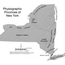
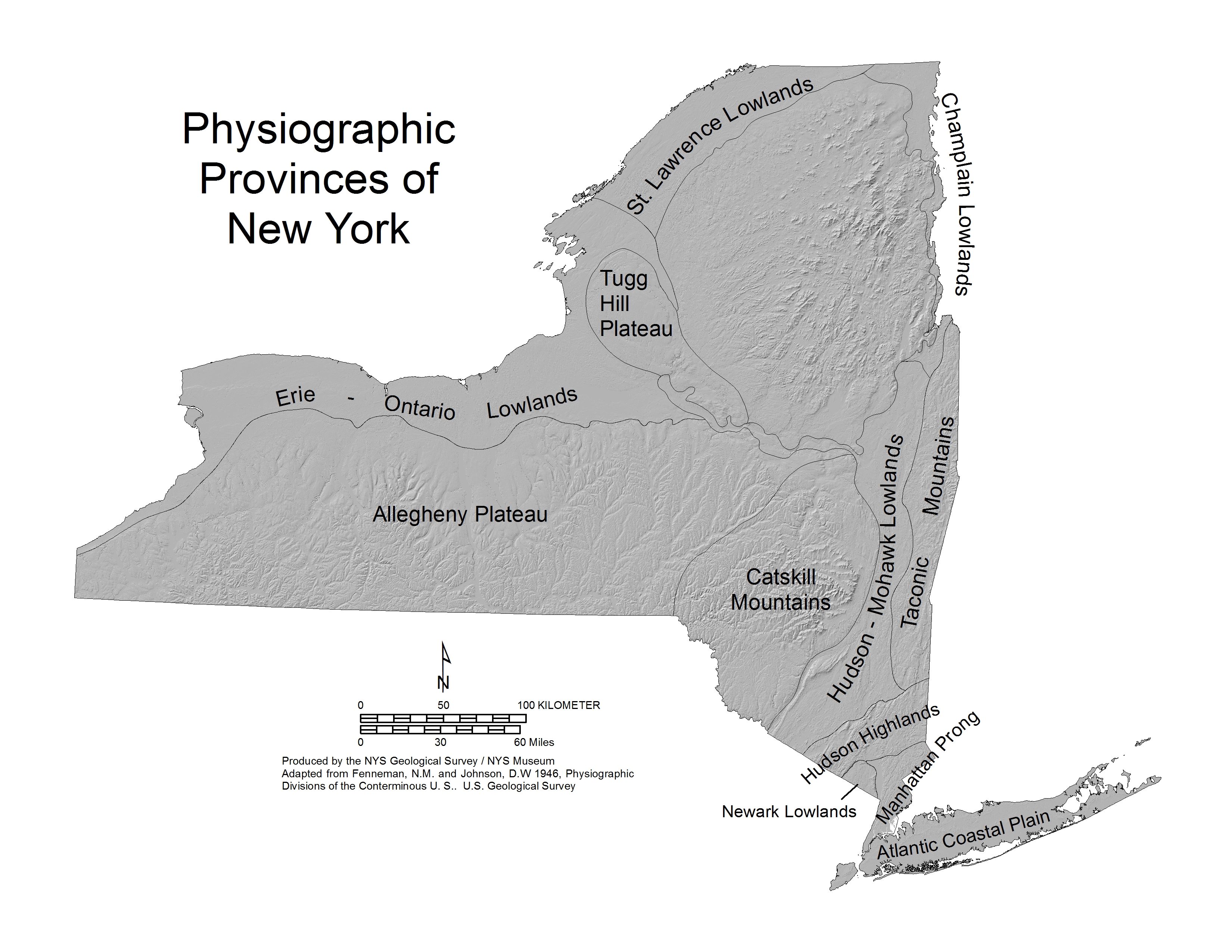
Physiographic Maps
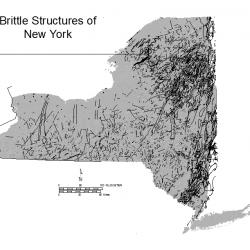
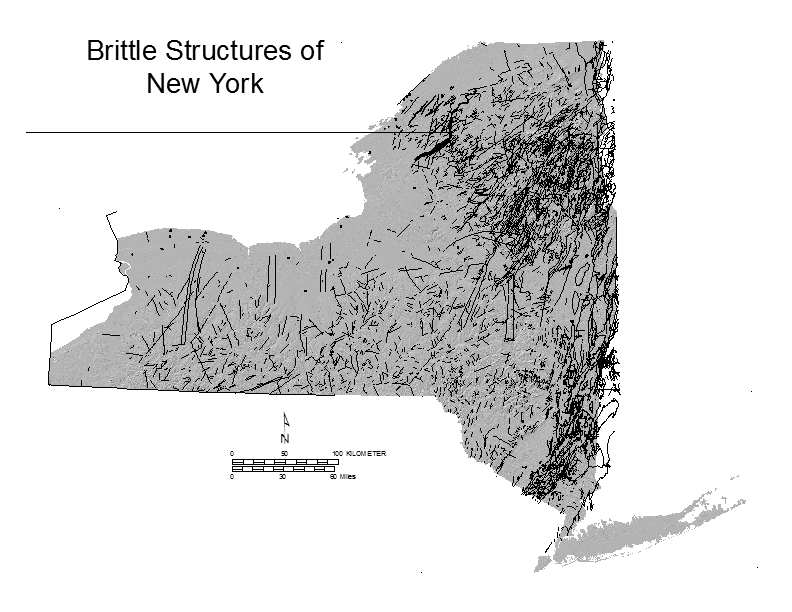
Brittle Structures of New York (nyfaults)
Disclaimer
While every effort has been made to insure the integrity of this digital data, the New York State Education Department ("NYSED") makes no representation or warranty, expressed or implied, with respect to its accuracy, completeness, or usefulness for any particular purpose or scale. NYSED assumes no liability for damages resulting from the use of any information, apparatus, method or process disclosed in this dataset, map or text, and urges independent site-specific verification of the information contained herein. Any use of trade, product or firm names is for descriptive purposes only and does not imply endorsement by NYSED.

The New York State Museum is a program of the University of the State of New York
New York State Education Department