

Welcome to the Cultural Resource Survey Program (CRSP) and Office of the State Archaeologist at the New York State Museum. The CRSP is an applied research program of the Museum's Research & Collections Division that provides research and assessment of archaeological and architectural resources for other state agencies. This extensive program assists these agencies with their State and Federal historic preservation mandates. The CRSP is the largest outside-funded Museum program and employs about one-sixth of the Research & Collections Division’s staff.
The CRSP currently manages hundreds of such research and assessment projects each year through its in-house staff and its outside contractors for various state agencies such as the New York State Department of Transportation, the Office of General Services, and the Department of Environmental Conservation.
The CRSP's work not only benefits state agencies by meeting regulatory requirements, but it also benefits the people of New York by collecting data on the history and prehistory of the state before loss through highway and other construction. The Museum curates artifacts and records generated by CRSP projects, thus making them available for research by current and future scholars. By benefiting archaeology, the Museum, and the other agencies – the CRSP is a model for interagency cooperation.
About the CRSP
NYPID -- it's not a state agency -- it's a research project!
Archaeological sites are only one category of cultural resources, but the vast majority of the CRSP’s projects do involve archaeology. Most of these projects are reconnaissance surveys to determine if, in fact, any archaeological sites are within a project’s area of potential effects (APE). Through a combination of historical and environmental background research, field investigations, and analysis — the goal of the CRSP’s field archaeology is to identify, preserve, and record the state’s archaeological resources for future research.

In some respects, cultural resource archaeology differs from traditional or academic research archaeology. Since the goal for cultural resource archaeologists is preservation, the emphasis is on the identification and assessment of archaeological resources rather than thorough excavation and interpretation of sites. In this sense, cultural resource archaeologists often “stop” just where traditional archaeologists “begin” – with the discovery of an archaeological site. Archaeology is a destructive process, since the excavations that create a record of a site do so through effectively dismantling it. The intent of cultural resource management is preservation and conservation of archaeological resources. We excavate only as much as is necessary to determine the presence, nature, dimensions, integrity, and age of a site. Full excavations are conducted only when a site cannot be avoided and left in place. Even then, the emphasis is primarily on thorough recording of the site for more extensive analysis by researchers in the future. Another difference is that while many archaeologists typically specialize in a specific geographic region or historical period, cultural resource archaeologists need to be generalists. A broad knowledge of the whole history of human activity in an area is needed for this type of archaeology. Whether a project area contains traces of a Native American camp from several thousands of years ago, a colonial-era settler’s cabin, or a late-19th century industrial mill – cultural resource archaeologists in the field need enough expertise to identify the artifacts and features of any type of site from any period of history.
Background Research & Screening
Most of the time, archaeological fieldwork actually begins in the library. The preliminary research for a project helps to see what might be found in a project area and to suggest what methods are likely to be most effective for the fieldwork. The background research involves a study of the local history, review of historical maps of the area, a search for known archaeological or historic properties in the vicinity, and a review of the environmental setting (including soil types, hydrography, and geology) of the project area. Working from this kind of information, a research and testing strategy is designed to reasonably ensure that any archaeological resources in the study area are found and identified. Even with the most thorough background research, one can never know for sure whether there are or aren’t archeological resources present in an area. Sites are quite often found in unexpected places, so the only way to really find out is to go out into the field and start digging.
Phase I — Reconnaissance Survey
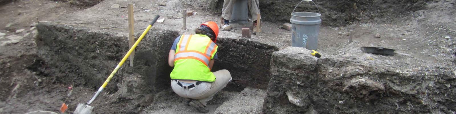
Sometimes referred to as a “Phase One Survey” or simply “Survey”, a Reconnaissance Survey is intended to do just that – to explore an area that may be affected by a state project, and to see what (if anything) is in the area that has the potential to be of historical or archaeological importance. The most common way of doing so is to dig a grid of shovel test pits (STPs) across the area. STPs are small round units (40 centimeters diameter, less than a foot and a half) that are excavated by hand, and dug down through the various layers of soil until a “sterile” layer is reached – often to depths of between 2 and 4 feet on most occasions. A “sterile” soil layer is, in this sense, one that contains no artifacts or evidence of human activity and is a naturally occurring part of soil formation (i.e. a sub-soil “B-Horizon” that generally predates human occupation in an area). The STPs are typically spaced 50 feet apart, which works out to an area sample of 16 STPs per acre. This sampling interval is close enough to be most likely to catch at least a glimpse of any buried archaeological resources, while still being as efficient as possible with the amount of work needed to test an area. The testing interval is shortened to 25 feet or less when artifacts are found or in a location where a site is strongly suspected (for example: near a map-documented structure or in an area where known sites are nearby). Notes are recorded for each STP that document the depths and descriptions of the soils encountered, what (if any) artifacts are found, and general observations about the pit and its surroundings (e.g. “on a lawn” or “lots of crushed gravels present in the first layer”). Any artifacts found are collected and bagged, then labeled with the STP number and in what soil layer they were found (i.e. the “provenience” of the artifact). These field notes and collections provide the lead archaeologist with all the pertinent information to determine whether the cultural material and features found (if any) warrant a designation as an archaeological site. If a site is found, then the question becomes whether the site is intact and/or significant enough to be eligible for the State or National Registers of Historic Places.
Phase II – Site Examination and Evaluation
A Site Examination or “Phase Two” Survey is meant to gather enough archaeological data to decide if a site is “significant” and to clarify the horizontal and vertical limits of the site’s area. The significance of an archaeological site is basically determined by whether the site has archaeological integrity (i.e. it remains largely intact) and whether it can provide historical information about the place, region, or people associated with the site. The spatial limits of the site are important for planning the other projects in the area in order to avoid affecting the site any more than necessary. A site examination typically involves excavating more STPs at a smaller interval than during the survey, and excavating a small number of larger excavation units and/or trenches to expose parts of the site for closer study of its soil layers and features (e.g. a foundation or hearth). Again, all of these excavations are carefully recorded and mapped and all the artifacts collected and catalogued by provenience. The intent of these test excavations is assessment, rather than interpretation, of an archaeological site. In a site examination, only a small percentage of the site’s area is tested intensively. Since the preferred outcome of cultural resource archaeology is to leave the site in place, a limited sample allows the archaeologists to make a determination about the integrity and significance of a site without removing more of the site’s resources than is minimally necessary. In some situations, however, there is no way to avoid the site and leave it undisturbed. If the site has been determined to be eligible for the State or National Register of Historic Places and it cannot be avoided, then the site needs to be excavated and recorded in full.
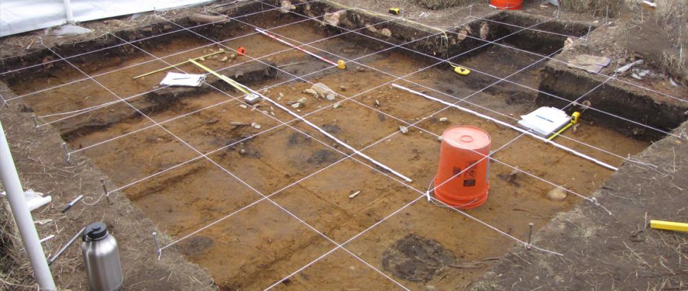
Phase III – Data Recovery and Site Mitigation
Data recovery is a long and slow process, requiring extensive field excavations and exhaustive historical research. More often, some form of site mitigation is proposed that minimizes (i.e. mitigates) the effects of construction on the site as a whole. This could mean excavating part of the site while changing the construction plans to avoid the rest, or possibly coming up with some way to protect the site from the construction by designing around it or “capping” it with some protective barrier. These decisions are made through a process of consultation between the government agencies involved, professional archaeologists, and the public and other people that may have some special interest in the site (e.g. the local community, related families, and Native descendents or representatives). A Data Recovery (or “Phase III”) is what most people think of as “real” archaeology – large area blocks of units, grids and survey lines stretched across a site, and lots of dirt being meticulously and methodically excavated and recorded. The intent of a data recovery excavation is the full recording of any and all archaeological data from a site that would otherwise be lost. If a site goes to this phase of excavation, it means that the site is both historically significant and unavoidably threatened by construction. In these situations, the only recourse is to create as thorough a record of the site as possible. While surveys and site examinations are intend to find and evaluate a site, a data recovery is meant to create as full an archaeological record of a site as can be done. This is accomplished through large-scale excavations of areas of interest identified in the prior phases combined with broad historical research on the location and its inhabitants. For historical sites, this can mean researching all available deed and census data related to the sites historical owners, old documents and letters, maps, newspaper articles, and any other references that can be found. For Native sites, it includes historical and archaeological reports about the site’s and regions prehistoric inhabitants and their way of life, consultation with tribal descendents, and comparisons with similar sites found throughout the state. The intent of all of this work is to provide future researchers with any and all information they might need to analyze and interpret the site, since the site itself will no longer be available.
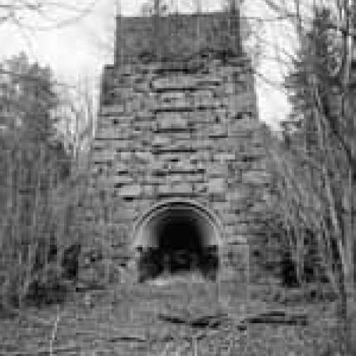
The Architectural Survey of the Cultural Resource Survey Program identifies and documents National Register of Historic Places architectural properties that are subject to highway construction and other impacts. Architectural properties may include buildings, bridges, monuments, cemeteries, and landscapes located in rural, village, and urban settings.
Properties may be significant under National Register Criteria A-D:
A. representing important historical events or trends,
B. association with an important individual,
C. representing an important type, period, or method of construction,
D. or as a primary source of information.These properties may have collective significance as an Historic District under these criteria. The context is often village or town wide but may be regional or statewide.
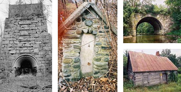
Reconnaissance surveys are conducted initially to identify properties that are eligible for the National Register. Often these are corridor surveys where highway reconstruction may affect mature trees, stone walls, slate sidewalks, and other associated features. The surveys expand the State Historic Preservation Office statewide inventory of National Register Eligible (NRE) properties while also generating a database for comparative research. Eligible properties have included log and plank houses, institutional and industrial complexes, village parks and cemeteries, stone arch bridges, and canal features.
Historic American Engineering Record (HAER) and Historic American Building Survey (HABS) documentations are prepared for eligible properties scheduled for removal or rehabilitation. The documentation consists of large format black and white photography with descriptive and historical information consistent with local, state, or national significance. Historic highway and canal bridges comprise the majority of these projects. Others have included a Dutch Colonial house to be rehabilitated as a museum, an Erie Canal store near a proposed roundabout, an 1880's firehouse located beneath a highway overpass, and an abandoned parkway service station.
Historic Setting Analyses are prepared where highway reconstruction may affect a village Historic District or an Historic Landscape. These provide contextual research and photo documentation comparing the historic and modern streetscape, with attention to street configurations, sidewalks, lighting, parks, trees, walls, and other features that may be affected. The intent is to guide context sensitive planning for the new highway. Projects have included Historic Districts in the Villages of Bainbridge, Canton, Chatham, and East Aurora and an historic parkway near Syracuse.
Mapping, Illustration, and Geographic Information Systems
An example of an artifact
density map.Archaeology is concerned with the spatial relationships of materials and features, and the recording and visualizing of these finds and their locations is an important aspect of the archaeological process. At the Cultural Resources Survey Program, artifact illustration, geographic information systems, and mapping techniques are utilized during the various phases of excavation and analysis.
Mapping of a CRSP project areas usually begins in the office using data and information available on the internet and from other agencies. This information is compiled to make a map appropriate for use by archaeologists in the field. The location of every excavated area and other features are recorded in the field and added to the map. Other drawings done in the field include plans of excavation units and wall profiles. These help the archaeologist in the determining the stratigraphic sequence of the site.
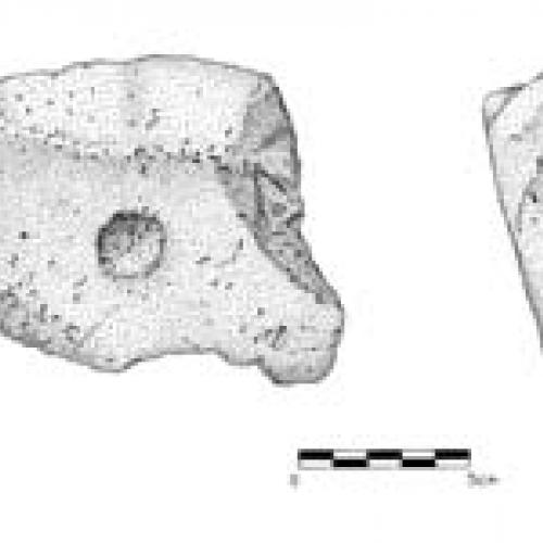
An illustration of a
pitted stone artifactGeographic Information Systems (GIS) is also used in mapping and analysis. With GIS, artifact density maps, soil survey maps, elevation models, and other thematic maps are produced. This spatial information is used to analyze what is found during the excavation and in planning future excavations.
Illustration is a useful tool for graphically showing the form and function of an artifact. Prehistoric and historic artifacts recovered from a site are illustrated to show the diagnostic features or identifiable characteristics of the objects. These artifacts may include prehistoric stone tools and flakes, like the pitted stone shown here. The type of artifact found can greatly aid in the interpretation of the archaeological site, therefore accurately drawing and presenting the find is important.
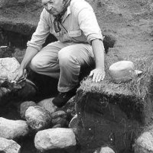
Dr. William A. Ritchie
c.1954The Cultural Resources Survey Program (CRSP) has been in existence since 1958 as an applied research program of the New York State Museum. The first cultural resource surveys were performed for the State Historic Trust under the direction of former state archaeologist Dr. William Ritchie and William A. Fenton, Assistant Commissioner of the New York State Museum and Science Service. Beginning in 1959, highway surveys were conducted for the New York State Department of Public Works to help them meet their compliance needs as part of the Federal-Aid Highway Act and the Highway Revenue Act of 1956.
Program guidance provided by the United States Department of Commerce for the preservation of archaeological and paleontological salvage call for the preservation for public use of "historical and prehistoric sites, buildings, and objects of national significance for the inspiration and benefit of the people of the United States" (Policy and Procedure Memorandum 20-7 1959:1). Robert Funk, who would succeed Ritchie as director of the program in 1965, Marian White and Charles Hays were among the first highway salvage archaeologists employed by the New York State Museum.
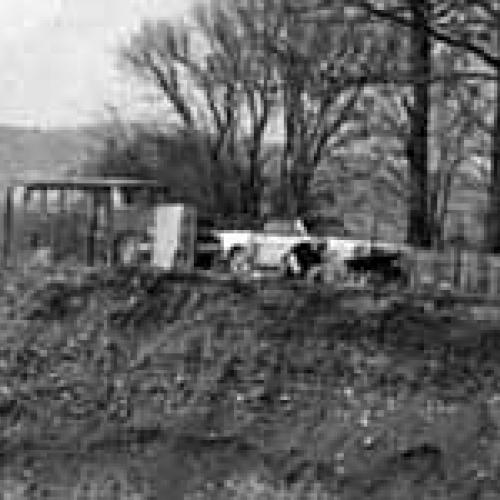
Surveying with the highway
salvage programThe program was formally organized as the Highway Salvage Program in 1963 through agreement between the New York State Education Department and the NYS Department of Public Works. From 1963 to 1977, the program would focus almost exclusively on large-scale surveys and the salvage for new highway construction through the southern tier and Hudson Valley of New York. The goal of these surveys was to identify and excavate, and recover "Indian artifacts" before their loss through construction (Funk 1968:1-2). In addition to in-house staff, archaeologists from local universities, historic societies, and museums became important consulting program partners. Early efforts by the University of Buffalo, Harpur College (Binghamton University), Rochester Museum, Syracuse University, the Nassau County Museum of Natural History, and the Buffalo and Erie County Historical Society resulted in the identification of many important sites including Roundtop, Engelbert, Zawatski Terrace, Comfort, Cottage, and Castle Garden.
survey.jpg
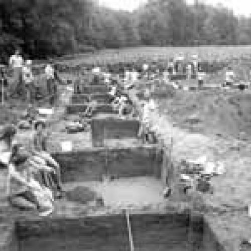
Dr. Robert Funk and crew, 1977.
From Salvage to Survey…
The Highway Salvage Program was re-named the Cultural Resources Survey Program in 1979 to take into account the growing nature of the program and the need to complete non-highway surveys for other agencies such as the Department of Correctional Services, the Office of Parks, Recreation, and Historic Preservation, and the New York State Department of Naval Affairs. Between 1979 and 1989, the program went through a significant period of growth with hundreds of miles of proposed highway corridor, canal alignment and railroad right of way being surveyed and scores of previously undocumented prehistoric and historic sites being identified.
Thousands of artifacts were recovered representing cultural activity from nearly 10,000 B.C. to the present. In addition, non-artifactual data on these sites have been collected and are preserved as detailed field notes, maps and charts. Information on standing structures dating from the late 18th through early 20th centuries were also inventoried and reported, increasing the architectural inventory files at the NYSM and the NYS Office of Parks, Recreation, and Historic Preservation. During this period, approximately 700 archaeological and 650 architectural reports were produced providing the Department of Transportation and other contracting agencies with the scientific basis for determining which sites require protection and what means of protection would be most appropriate.
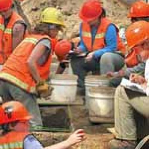
CRSP work at Fort
Edward, 2007.Survey staff has played an increasingly significant role in the identification and preservation of cultural resources in the state since 1989. The program is not only able to conduct effective field investigations on short notice over a wide area of the State, it is also able to effectively draw on the resources of the State Library and State Archives in developing its documentary research reports. The range of cultural resource studies undertaken by staff reflects the range of cultural resource research areas in which the program has become involved. These studies range from an architectural inventory of a 19th century urban neighborhood in Troy, Rensselaer County, where standing structures were the primary focus, to an historical reconstruction project in Comstock, Washington County, where documentary sources were used to recreate on paper a tiny 19th century village that was completely wiped out by the enlargement of the Old Champlain Canal a century ago. Nearby, an archaeological study of a vacant lot in the City of Cohoes produced evidence of an 18th century Dutch house site, and underneath it, an intact Native American site dating back over 4,000 years.
Not Only Archaeology…
In addition to archaeological studies, the survey completes architectural surveys and HABS/HAER studies of architectural properties when the existing landscape is modified. A recent architectural survey near Glenville, Schenectady County produced two unique examples of architectural resources. Conifer Park, a residential treatment center, was originally built as a tuberculosis sanatorium in 1927. An architectural drawing dated that year shows that the brick building remained fairly unaltered for eighty years. This building is not only historically important as a rare example of a tuberculosis hospital still standing, but also as a structure built in the Spanish Eclectic architectural style, a style more likely to be seen in Florida and the Southwest. Also discovered, was a buried trolley bridge with two arches (one for the north line, the other for the south line). Built in 1904, this bridge carried the Boston and Maine Railroad over the trolley tracks of the Schenectady Railroad Company. The trolleys traveled between Schenectady and Ballston until 1941, and the bridge was buried shortly thereafter. This bridge is an important historical resource as one of the last surviving intact features of the trolley company.
For the Public...
An important component of the scientific study of these resources is the need to disseminate information about these studies to the public. Each year, staff disseminates information about survey projects through the preparation of brochures, publications in peer-review journal articles, exhibits, field and lab open houses, and lectures. The New York State Museum's Cultural Resources Survey Program Bulletin Series is designed to publish the results of exemplary reports produced by the program. Internship programs allow students to learn about cultural resource management and stewardship of the archaeological record.
Bibliography
- Funk, R.E. 1968 Highway Salvage Archaeology: 1963-1968. Unpublished Manuscript, Archaeological Files of the Cultural Resources Survey Program, New York State Museum, Albany, New York.
- Funk, R.E. 1985 Division of Historical and Anthropological Sevices-5 Year Report (1980-1985) for the Public Archaeology Section. Unpublished Manuscript, Cultural Resources Survey Program, New York State Museum, Albany, New York.
- United States Department of Public Works 1959 Policy and Procedure Memorandum for the Salvage of Archaeological and Paleontological Resources. Policy Memorandum 20-7:1-2.


