

Geoarchaeology
The lab is dedicated to advancing the practical integration of geoarchaeological approaches into archaeological field and laboratory work.
Geoarchaeological work on New York sites is recorded in a series of technical reports curated within the Quaternary Landscape Materials collection. The oldest site in this dataset documents the important find of a Late Pleistocene paleosol buried beneath eolian sand dune deposits in Saratoga County, while the youngest sites in the series document the development of Historic-period soil biomantles. The geoarchaeology collection includes material objects like soil samples taken in support of field and laboratory work, in addition to value-added field and web-based digital data sets used in stratigraphic and GIS analyses of the studied sites. Collectively, these data are useful resources within broader research frameworks that help us gain a better understanding of natural and human ecological relationships in the past.
Most archaeological sites in New York are found in surface soil profiles, so the methods I use are those that treat soils from a scientific (not an engineering) perspective, in the branch of soil science called pedology, and more specifically the study of soil geomorphology (see for e.g., “Soils: Genesis and Geomorphology” by R. Schaetzl and S. Anderson, 2005, Cambridge University Press). To record observations I use the system developed by the USDA - Natural Resources Conservation Service (“Field Book for Describing and Sampling Soils” www.nrcs.usda.gov), modified to accommodate geological and archaeological observations, in the tradition of many American geoarchaeologists (see for e.g., “Soils in Archaeological Research” by V.T. Holliday, 2008, Oxford University Press).
Field equipment at the NYSM Geoarchaeology Lab includes a trailer-mounted Giddings hydraulic soil probe to extract solid sediment cores, a Leica TC805 total station and associated surveying equipment to generate detailed elevational data, and a variety of useful hand tools, including an AMS auger with extensions capable of reaching depths of 5 m. The lab is outfitted to conduct particle size analyses of soils and sediment utilizing the pipette procedure for the <2 mm soil fractions, and nested dry sieves for the >2 mm soil fractions. To study and date river deposits, the lab is equipped to recover uncarbonized plant macrofossil remains using a wet-sieve technique.
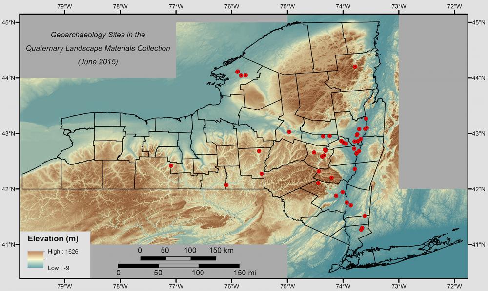
Geoarchaeology Sites in the NYSM’s Quaternary Landscape Materials Collection

Drilling in the Schoharie Creek floodplain, east-central New York. Coring can be an efficient and cost-effective way to study the complex 3D nature of floodplain deposits.
User not selected