

Shawangunk Ridge
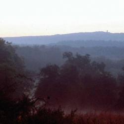
The Shawangunks of southeastern New York are a long, high ridge that rises west of the Hudson River, and runs southwest as far as Virginia. From southwest of Kingston to Port Jervis, a chain of state parks, preserves and state forests, preserve most of the ridge in New York as parklands and wildlands. Pronounced shuh-WAN-gunk, or SHON-gum by locals, the "Gunks" are known widely for their dramatic cliffs and landscapes, dwarf pine barren forest ecosystems, "ice caves", and classic rock climbing. The character of the Shawangunks are underpinned by their unique geology—perhaps most simply stated as "quartz, and more quartz".
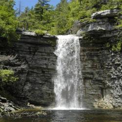
Hiking, rock climbing and the wild beauty of the Shawangunks draw many visitors to the ridge today, at such places as Minnewaska State Park, Sam’s Point Preserve, the Mohonk Preserve and Mohonk Mountain House, and state forests. In the late 1800s, the Gunks were a retreat for the well-to-do, who stayed in luxurious hotels nestled atop the cliffs above crystal-clear lakes. These included the now-gone Cliff House and Wildmere hotels at Lake Minnewaska, and the Mohonk Mountain House, which is still in operation today.
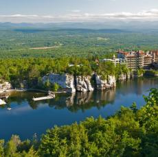
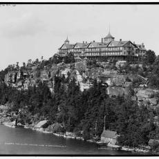
Mohonk Mountain House
Modern photo of the Mohonk Mountain House at Mohonk, on the Shawangunk Ridge (Photo from Wikipedia)
Mohonk Mountain House
Modern photo of the Mohonk Mountain House at Mohonk, on the Shawangunk Ridge (Photo from Wikipedia)
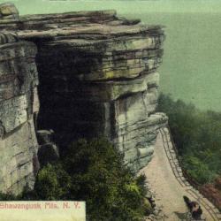
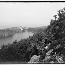
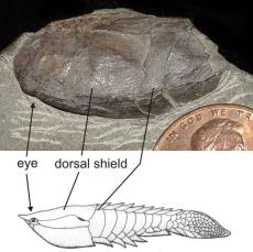
Cliff House
Historic photo of the Cliff House on the cliffs above Minnewaska Lake. This old resort hotel, now on the property of Minnewaska State Park, no longer exists. Photo taken around 1903. (photo from the Library of Congress)
Geological Features
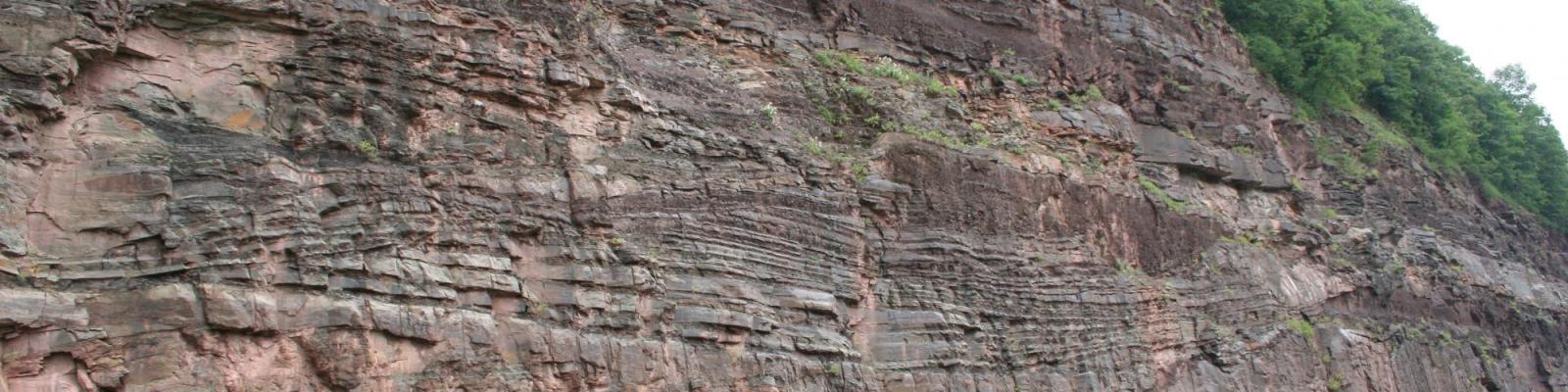
The rocks of the Shawangunks are chiefly made of sedimentary conglomerate and sandstone, with a small amount of shale. They were initially deposited as quartz gravel and sand, eroded from the Appalachian mountains over several million years, back around 430 million years ago (during the Silurian Period of geologists). In New York these quartz-rich sediments were dropped by "braided" rivers on their way to a shallow sea in central to western New York. As the sediments became buried deeper and deeper by more sediments, quartz crystallized out of groundwater in the sediments, and cemented the gravel and sand together. Hence the statement, "quartz and more quartz."
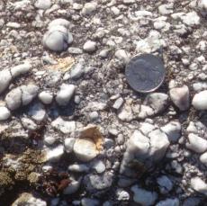
Quartz Pebbles
Milky quartz pebbles make up the conglomerate of the lower part of the Shawangunk Formation in the Shawangunks. Higher parts of the Shawangunk Formation chiefly consist of quartz sandstones. U.S. quarter for scale. (photo by C. Ver Straeten)
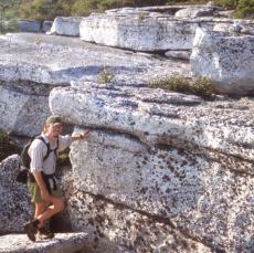
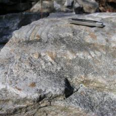
Lower Shawangunk Formation
Outcrop photo of the Shawangunk Formation at Sam's Point Preserve. The rocks consist of quartz pebbles and/or sand grains, cemented together by quartz. Quartz is a very hard mineral (8 of 10 on a hardness scale, where diamond is 10). The rocks of the Shawangunk Formation consist largely of quartz pebbles and or quartz sand, cemented together by quartz. They are very resistant to physical and chemical breakdown relative to surrounding rocks. That is why the Shawangunk Ridge stands high above the adjacent lowlands. (photo by C. Ver Straeten)
Quartz (SiO2) is one of the harder minerals on earth (7 on a scale of 1-10, with diamonds being 10), which makes it hard to erode, resulting in the high-standing Shawangunk Ridge. In addition, quartz-rich rocks are poor in other minerals and nutrients. Few plants flourish, or even survive on the nutrient-poor sandy soils of the Gunks, especially combined with challenging physical conditions on the ridge-top. The result in many areas is dwarf pine barren forests, with very low biological diversity. These forests are also adapted to occasional fires, such as a large fire in 2008 that burned 3100 acres on the ridge at and near Minnewaska State Park. A fire twice that size swept across the Shawangunk Ridge in 1947. That fire was largely fought for over two days by a single man, who then recruited local high school students to help out.
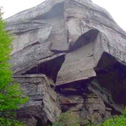
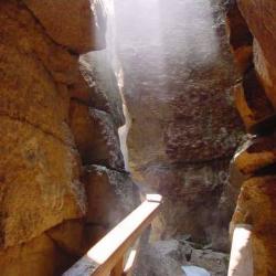
The very hard, resistant nature of the "quartz and more quartz" conglomerates and sandstones (the "Shawangunk Formation" to geologists) results in various features on the ridge. While hard to erode, the rocks were fractured in the geological past. Long, often vertical cracks, called "joints" penetrate through the Shawangunk rocks. In some areas of the ridge tall blocks of rock, sometimes up to 120 feet high, spread apart between the joints and form deep crevices. These crevices remain cool through the summer—cool enough some years to retain snow that fell the previous winter. These are "ice caves", as seen at Sam’s Point Preserve on the ridge above Ellenville.
Fossils are rare in the Shawangunk Formation. This largely reflects deposition of the gravel and sand in river channels, on land. Rare fossils found over the years in the Shawangunk include small eurypterids and armored fish. This is in sharp contrast to the same age rocks found in central to western New York, deposited in a shallow seaway that covered many of the eastern states at times. This includes the rocks seen at Niagara Falls, such as the Rochester Shale, which is famous for its shelly fossils, including finely preserved brachiopods, crinoids and trilobites.
Eurypterid
Fossils are rare in the Shawangunk Formation. Here we see the head of the small eurypterid Parastylonurus myops with mirrored arc for eyes, and various small pieces, found locally in thin shale layers. From the NY State Museum Paleontology Collection. Edge of U.S. penny for scale.
Vernonaspis
Rare fish fossils have also been found in the Shawangunk Formation. Here we see bony head shield and body segments that covered parts of the armored ostracoderm fish, Vernonaspis vaningeni. A reconstruction of a somewhat similar ostracoderm fish, Anglaspis, is shown. From the NY State Museum Paleontology Collection. Edge of U.S. penny for scale.
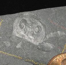
Mystery Fossil
Top view of a mystery fossil from the Shawangunk Formation. Note the oval-shaped, segmented area in the upper center of the rock, and another narrow band to the lower left of that. What you are seeing is the impression of the inside (underside?) of the skeleton of a shelly animal. What might it be? It appears to be a poorly preserved internal mold of some type of segmented animal, like some type of arthropod. Fossil found by New York State Museum geologist Dr. Chuck Ver Straeten during fieldwork. Small pocketknife (~3 inches long) for scale. (photo by C. Ver Straeten)
Geology, In Greater Depth
The quartz-rich conglomerate and sandstone and small amounts of shale of the Silurian-age Shawangunk Formation were deposited in largely terrestrial environments. Deep erosion of the Appalachian Mountains following the Ordovician-age Taconic Orogeny resulted in transport and deposition of large amounts of milky quartz in southeastern New York, seen as the white pebbles of the Shawangunk Formation.
The lowermost Shawangunk conglomerates sit on an ancient erosion surface (the "Taconic unconformity"). The erosion surface is estimated to represent approximately 20-30 million years. Below that are shales and sandstones deposited in deeper marine waters (a few hundred feet deep at most) during the Late Ordovician Period (Martinsburg Formation).
The Shawangunk Formation is thickest northeast of Port Jervis, where it is as much as 1400 feet (425 meters) thick. It thins to the northeast and disappears a little southwest of Kingston. In its thickest areas, it may have been deposited over as much as 15 million years or more—at the same time that a shallow sea covered central to western New York and much of the eastern U.S.
Cross-bedding, channel structures and other features in the conglomerates and sandstones indicate the rocks were chiefly deposited in "braided" rivers, which feature many small, interweaving channels. They are commonly seen draining mountainous areas. However, the finding of a trilobite fossil in 2004 indicates that there were times when sea level rose enough that the seaway of central to western New York flooded the Shawangunks area for a geologically short time. This is seen in some rock outcrops by layering that indicates the action of tides ("herring-bone cross laminations").
The very hard, resistant nature of the quartz-rich Shawangunk Formation rocks made them ideal for millstones, used for grinding grain. Mined from the slopes of the ridge and shipped out via the Delaware and Hudson canal during the 1800s, they were a major source of millstones in the U.S. Old quarry pits were worked by hand, and they are commonly seen in some areas. Lead was also formerly mined in the Shawangunks.
That same hard, resistant character of the rocks, along with the resulting high cliffs, also makes the Shawangunks ideal for rock climbers, who come to climb from around the world. It is said to be the most-visited rock climbing area in North America. Another famous mountain climbing site in the eastern U.S., called Seneca Rocks (in eastern West Virginia), is made of the same quartz-rich rocks deposited at the same time.
During the last glaciation of New York (which at its peak about 24,000 years ago covered all of New York except around Alleghany State Park in the southern tier) the Shawangunks were buried beneath thick glacial ice. Evidence of that glacial episode is found as scratches and gouges on the surface of the hard quartz-rich rocks ("glacial striations"), and as various sediment deposits including "glacial till", a mix of various sized-sediments from clay to sand to pebbles and boulders.
Acknowledgements:
Thanks to Laura Conner (Minnewaska State Park, NYS Office of Parks, Recreation and Historic Preservation), Heidi Wagner (Sam’s Point Preserve, Nature Conservancy) for information and images, and to Craig Williams (historian, NY State Museum) for additional information and images.
Related Links:
Minnewaska State Park
http://nysparks.com/parks/127/details.aspx, http://lakeminnewaska.org/h…;
Sam’s Point Preserve
http://www.nature.org/ourinitiatives/regions/northamerica/unitedstates/…
placesweprotect/easternnewyork/wherewework/eastern-sams-point-preserve.xml
Mohonk Preserve
http://www.mohonkpreserve.org/
Mohonk Mountain House
http://www.mohonk.com/
Shawangunk Ridge (Wikipedia)
http://en.wikipedia.org/wiki/Shawangunk_Ridge
Shawangunk Mountains Scenic Byway
http://mtnscenicbyway.org/index.html, http://mtnscenicbyway.org/history…;(history)
Shawangunk millstones
http://hudsonvalleygeologist.blogspot.com/2010/03/picture-of-week-mills…;
Shawangunks Geology
http://hudsonvalleygeologist.blogspot.com/2010/01/picture-of-week-clove…;
http://www.gunkguide.com/09Nov/09031-geo.html
http://tin.er.usgs.gov/geology/state/sgmc-unit.php?unit=NJSs%3B7
http://pubs.usgs.gov/bul/1839l/report.pdf (a recent detailed geologic study of Silurian-age rocks of the Shawangunk Ridge; by Jack Epstein, 1993)
NY
United States