

New York State Museum Earthquake Center
Delve into the intriguing world of earthquakes, and discover how New York, despite its location far from tectonic plate boundaries, experiences its own seismic activity.
Earthquakes in New York?
Yes, earthquakes do occur on a regular basis in New York.
Most people think of places like California when they hear the word "earthquake", but earthquake activity is normal in the eastern United States. Thousands of earthquakes have been recorded in New York and nearby areas over the past century. The major difference between East Coast and West Coast quakes is the frequency of damage-causing events. Most New York quakes cause little or no damage, while West Coast quakes are often much more destructive.
What Are Earthquakes?
Earthquakes usually occur from movement between the tectonic plates that make up the Earth's crust, with about 90% happening at plate boundaries. Plates tear apart, collide, and slide past each other along faults, causing earthquakes. Areas known for frequent seismic activity like California, the southwest Pacific, Japan, and Iceland are located on these boundaries.
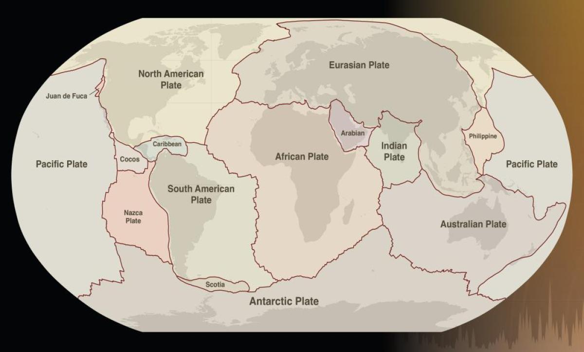
New York isn't on a tectonic plate boundary. Geologists think earthquakes happen here because of movements in old, weak areas of the Earth's crust. They also suggest that these earthquakes may be due to mantle movements pushing the crust up, as is happening in the Adirondacks, or the crust is rebounding since the last Ice Age's glacial ice melted.
Above or Below?
We often feel earthquakes on the surface, but they originate below us at a point called the hypocenter. The closer the hypocenter is to the surface, the more strongly the earthquake can be felt. Very strong quakes with deep hypocenters might not be felt at all, while weaker quakes near the surface can cause significant damage.
The epicenter is the point directly above the hypocenter on the surface and is used to mark the earthquake’s location on a map.

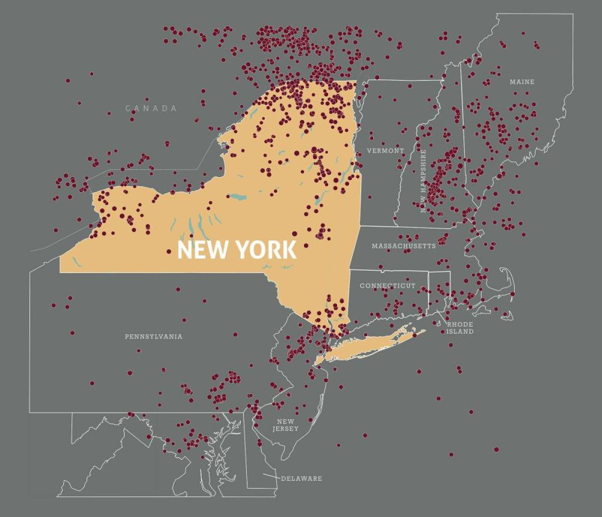
New York Quakes
The Richter Scale measures earthquakes by the energy they release. Earthquakes under magnitude 3 are recorded by scientific instruments but usually not felt, while those of magnitude 8 or higher can cause significant damage over large areas.
Most New York earthquakes are well under magnitude 5. However, notable earthquakes above 5 have occurred in Attica (1929), New York City (1884 and 1937), and Plattsburgh (2002). While rare, damaging earthquakes can occur in New York. The northern part of the state and the New York City region are slightly more at risk.

New York's Biggest Earthquake
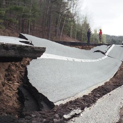
On September 4, 1944, a 5.8 magnitude earthquake rocked St Lawrence County. Centered between Massena, New York, and Cornwall, Ontario, Canada, the quake caused $2 million in damage. Massena saw significant damage to chimneys, plumbing and house foundations. In nearby Hogansburg the ground cracked in many places. Numerous wells across St. Lawrence County went dry.
The quake was felt across 450,000 square kilometers, into New England, Delaware, Maryland, New Jersey, Pennsylvania, Michigan, and Ohio.
Monitoring and Measuring Earthquakes
Seismic waves are vibrations from earthquakes or other events that travel through the Earth. These vibrations are recorded by scientific instruments called seismographs. Sensitive seismographs can detect strong earthquakes from around the world. The time, location, and magnitude of an earthquake can be seen on the recorded data.
The seismograph records data as a wavy line called a seismogram. The seismogram shows data in one-hour sections over a full day. When there is little or no seismic activity, the wavy line is almost flat. As seismic activity increases, the waves become taller and closer together. The taller the waves, the stronger the seismic activity.
View an ongoing record of seismic energy detected by a seismograph at the U.S. Geologic Survey’s seismic station in Troy, NY. The timestamps on the seismogram are in a standardized global format, Coordinated Universal Time (UTC), which is four hours ahead of local Eastern Standard Time.
New York State Museum Geologists Discuss Earthquakes!
Geological Specimens on View

Calc-silicate schist
Lake George, NY
Under certain conditions, rocks bend and fold rather than break. Folded rocks are bent or curved due to forces such as tectonic stress, creating wave-like structures. Some folds are small, as here; others are landscape size.
NYSM 2817, Geology-Minerals Collection
Slickensides
Slickensides are polished, striated rock surfaces that are a result of friction along a fault.
NYSM 19418 & 19451, Geology-Minerals Collection


Faults
These rocks show faults. Faults are fractures in Earth’s crust where blocks of rock have moved relative to each other. Some faults are very large, like the San Andreas Fault in California, while others are very small.
NYSM S1721 & S1722, Sedimentary Rocks Collection

